Overview
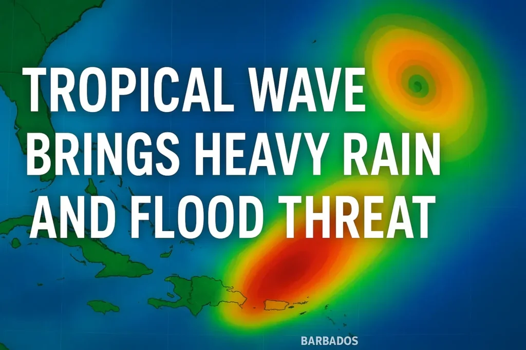
A strong tropical wave is moving into the eastern Caribbean, bringing with it rounds of heavy rain, gusty winds, and localised flooding. While the system is not yet a named storm, the widespread tropical moisture it carries could create significant impacts across several islands over the next few days.
Current Situation in the Caribbean
- Eastern Caribbean Islands: Barbados, Trinidad, Dominica, Martinique, St. Lucia, St. Vincent, the Grenadines, and Grenada are already seeing increasing showers and thunderstorms.
- Flooding Concerns: Rainfall totals may exceed 100 mm (4 inches) in some locations, raising the risk of flash flooding and mudslides in vulnerable areas.
- Short-Term Outlook: Development into a tropical depression is possible but remains a low chance within the next 24 to 48 hours.
Potential Tropical Development
Why Conditions Are Borderline
- Wind Shear: Currently, high wind shear is limiting organisation in the eastern Caribbean.
- Warm Waters: Sea-surface temperatures are exceptionally warm, around 31°C (near 90°F), especially in the western Caribbean and Gulf of Mexico. This could support strengthening later in the week.
- Model Uncertainty: While American, European, and Canadian models show low development chances, the ICON model suggests a tropical depression or storm could form as the system drifts westward toward the Yucatán Peninsula.
Rainfall by Region
- Barbados & Trinidad: Rounds of heavy downpours and gusty winds are expected through tonight.
- Martinique, Dominica & St. Lucia: Risk of flash flooding as rainfall intensifies into Monday.
- Grenada & St. Vincent: Scattered thunderstorms and periods of flooding rain.
- Jamaica, Cayman Islands & Cuba (Midweek): Watching for potential impacts as the system enters the western Caribbean.
- Central America (Honduras, Nicaragua, Belize, Yucatán): Heavier rainfall possible later in the week, depending on the system’s track and organisation.
Other Systems in the Atlantic
Another tropical system, located east of Bermuda, is expected to remain out at sea. While it may bring higher surf and swells to nearby waters, it poses no direct threat to land.
Key Risks to Watch
- Flash Flooding: Even without development, rainfall totals could overwhelm local drainage in the Lesser Antilles.
- Rough Seas: Elevated swells and choppy waters will affect the central and western Caribbean throughout the week.
- Tropical Storm Potential: If the system organises, the next name on the 2025 Atlantic storm list is Gabrielle.
Preparedness Tips
- Monitor local weather alerts and updates.
- Avoid driving through flooded areas.
- Secure outdoor items that gusty winds could impact.
- Coastal communities should be cautious of rough surf and rip currents.
Final Outlook
While development chances remain low in the short term, this tropical wave is already producing dangerous weather conditions. The primary threat is heavy rainfall and flooding across parts of the Caribbean. Longer term, the system could organise as it moves into the warmer waters of the western Caribbean later this week.
Stay alert, stay safe, and continue monitoring trusted forecasts for the latest updates.